High Rock Lookout – Hiking in Gifford Pinchot National Forest


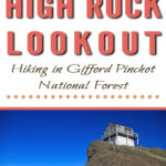


High Rock Lookout – Hiking in Gifford Pinchot National Forest

High Rock Lookout is a popular 3.2 mile round trip hike with 1,365 feet of elevation gain to a fire tower that was built in 1929. This moderately difficult hike leads to postcard-worthy 360-degree views that definitely have that Pacific Northwest wow factor! If you are just visiting Washington State or even a local who has yet to see this beauty, High Rock Lookout is a great hike to check out. It's sweeping views of Mount Rainier and the surrounding mountains and valley below are absolutely incredible.


High Rock Lookout Quick Facts
Miles: 3.2 Miles Round Trip
Elevation Gain: 1365 feet
Elevation at Highest Point: 5685 feet
Trail Type: Out-and-Back Trail
Trail Number: #266
Dogs: Yes Dogs are Allowed
Toilets: None
Level of difficulty: Moderate
Average Time to Hike: 1-2 hours
Best Season: June-October
Co-ordinates: 46.6664, -121.8913
Parking Permit: Required: Northwest Forest Pass or America the Beautiful Pass

Driving to the Fire Tower
When driving to the trailhead be ready for a rough road. There are tons of potholes and ruts on the Forest Service road leading to the trailhead. Forest road 84 is in much better shape than Forest road 85. Directions are at the bottom of this blog post.
There is limited parking at the trailhead with enough space for approximately 12+ cars. There are 3 spots that are accessible to high clearance vehicles. With the lack of parking spaces, it would be a good idea to arrive at this trailhead early.

Right from the parking lot for High Rock Lookout you can see the fire tower.
The Trail:
The trail to High Rock Lookout is basically straight up. You quickly gain 1,365 feet of elevation within a span of 1.6 miles. This short little hike does not pass by any streams so make sure you bring plenty of water.


The majority of the trail is clear and very easy to navigate, with only some roots in spots. Along the way in the beginning portion of the hike, there are a few benches to sit but there are none on the second leg of the hike. The first bench is at the 0.7-mile mark and the second bench is about 0.9 miles in.

The trail is mostly forested with some gaps through the trees where at times you can see Mt. Rainier directly in front of you poking through the tree canopy. At the 1.3 mile mark, you get your first real good clear opening through the trees. At this rocky viewpoint, you can see the sprawling vista of the valley below and an up-close view of Mt. Adams.


At the end of the hike you will emerge from the forested canopy and start climbing up rocky granite the rest of the way to the Fire Tower.


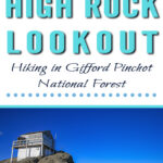
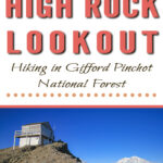
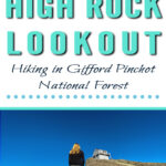
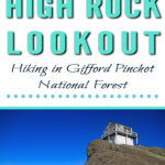
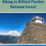
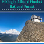
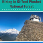
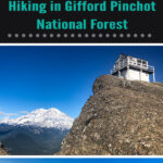
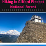
Once you reach the granite rock face you will see Mount Rainier on full display towering behind the High Rock Lookout fire tower.

Sitting at an elevation of 5,685 feet, this old fire tower has breathtaking panoramic 360-degree views. From the top, you can see the Tatoosh mountain range, Sawtooth Ridge, the Goat Rocks, Mount Adams, Mount St. Helens, Mount Hood to the south in the far distance, and sitting directly behind the fire tower is an up-close postcard-worthy view of Mount Rainier. If you are not prone to vertigo you can look down from the lookout and see Lake Cora sitting at a staggering 1800 feet in the valley below, with views of the Nisqually River.


High Rock Lookout was built in 1929 and is one of the last three Fire towers remaining in Gifford Pinchot National Forest. This historic fire tower is no longer staffed by the forest services but the tower is often left open for day-use visitors. On the inside of the Fire tower, there is a logbook that hikers can sign. You can see notes, and names of visitors from all around the world scribbled on the sign-in pages.


Good to Note:
High Rock Lookout has dangerous ledges with sudden dropoffs of more than 600 feet. Despite this hike allowing dogs, this may be a trail that you want to leave your four-legged friend at home. It is critical to keep an eye on children at all times. There are no guard rails and it would be very easy to fall if not paying attention.


Watch Our Hike to High Rock Lookout
For information on the current road status to the trail visit the Gifford-Pinchot National Forest website.
Directions:
Getting to the Trailhead
From the little town Elbe, heading along State Route 7, you follow SR-706 east for about 10.1 miles. After you pass Ashford, it is about two more miles till your next turn. You will make a right onto Kernahan Road.
Follow Kernahan Road 1.4 miles. After the 1.4 mile mark, the road will curve to the left becoming Skate Creek Road. You go down Skate Creek Road for about 3.3 miles. After 3.3 miles you will turn onto FR-84. FR-84 is a rough dirt road usually filled with potholes that you continue driving on for 6.5 miles. Keep right when there is a fork in the road. The road will become 8440. You will continue on 8440 for approximately 2.6 miles till the road widens out and you will see parking and the start of the trail.
Co-ordinates: 46.6664, -121.8913
Other Blog Post's You May Like
High Rock Lookout Photo Gallery
5 Reasons You Should Visit Mt. Rainier in the Fall
How to Successfully Do A Sunrise Hike Up Mt. Townsend
Night Hiking Dangers To Be Aware Of When Planning Your Next Pre-Dawn Adventure
What to Pack for a Sunrise Hike
Myrtle Falls & Edith Creek – Paradise Mt. Rainier
Narada Falls (Paradise Mt. Rainier Hikes)
Franklin Falls Easy Beautiful Winter Hike Near Seattle
Marymere Falls – Easy Hike in Olympic National Park

Want To Fill Your Life With Adventure?
Join our newsletter for an adrenaline-fueled journey! Receive exclusive updates on travel tips, gear reviews, epic hikes, captivating stories, and inspiration to turn your dreams into reality.
Don't just dream it, live it! Get Out There!


")