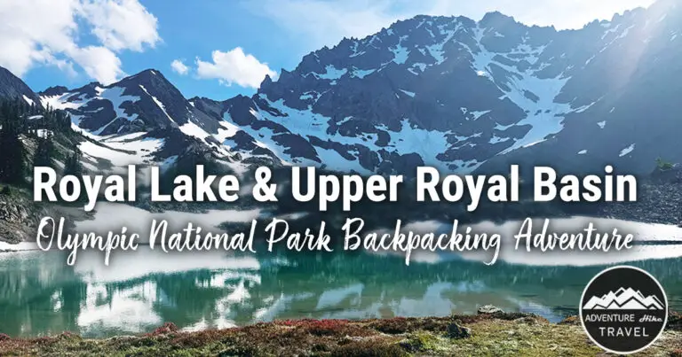
Royal Basin & Royal Lake Backpacking In Olympic National Park
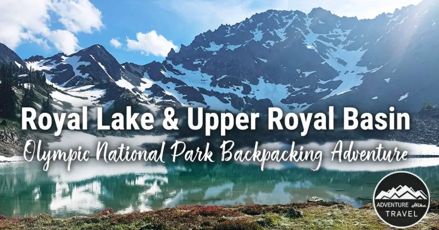
If you’re dreaming of an alpine backpacking trip filled with turquoise lakes, wildflower meadows, and jaw-dropping mountain views, the Royal Basin Trail in Olympic National Park deserves a top spot on your list. This incredible route winds through lush old-growth forest, past cascading waterfalls, and leads you deep into one of the most breathtaking alpine areas of Olympic National Park. This was my first backpacking trip many years ago, and I was so excited to come back here to this gorgeous spot this past summer.


Royal Lake and Upper Royal Basin — Quick Trail Facts
Trail Overview:
-
Hike Name: Royal Basin via Royal Lake
-
Location: Olympic National Park
-
Trail Type: Out-and-back
-
Hike Type: Overnight backpacking trip
Distances:
-
To Lower Royal Lake: 7.2 miles (14.4 miles round-trip)
-
Full Trip to Upper Royal Basin: 16–21 miles round-trip (depending on route)
Elevation:
-
Elevation Gain to Lower Royal Lake: ~2,660 feet
-
Elevation Gain to Upper Royal Basin: ~3,400 feet
-
Highest Point: ~5,700 feet
-
Lower Royal Lake Elevation: ~5,100 feet
-
Upper Royal Basin Elevation: ~5,700 feet
Difficulty: Hard
Trailhead & Access:
-
Trailhead: Upper Dungeness Trail (#833.2), then switch to Royal Creek Trail (#832)
-
Pass Required: Northwest Forest Pass or America the Beautiful Pass
-
Camping Permits: Required (available on Recreation.gov)
Best Season: July through mid-October
Restrictions & Guidelines:
-
Dogs: Not allowed
-
Horses / Stock: Not allowed
-
Maximum Party Size: 12 people
-
Cell Service: None
Travel Info:
-
Distance from Seattle: ~2 hours 40 minutes


Quick Overview of Royal Lake and Upper Royal Basin
Backpacking to Royal Lake and Royal Basin is an unforgettable journey into the heart of the Olympic Mountains. This is hands down one of my favorite backpacking destinations in Washington State. Depending on how much wandering around the Upper Basin, this hike round-trip is anywhere from 16 – 21miles. The trail to Royal Lake stretches about 7.2 miles, with an additional 0.8+ miles depending on the route you take to Upper Royal Basin. The path to Upper Royal is definitely more rugged and less-maintained, but the narrow goat path leads to some of the most stunning alpine views in the Olympic Wilderness.
The adventure begins with a gentle stroll through dense, moss-draped forests. Towering firs and hemlocks line the trail, and the steady murmur of Royal Creek and cascading waterfalls accompanies you, setting a serene and magical tone for the hike.
As the trail climbs higher, you leave the moss-carpeted forest behind and move into rocky alpine terrain, alternating between exposed rocks and scattered trees. Eventually, the forest opens up to Lower Royal Lake. This stunning alpine lake features sparkling waters where you can often see trout swimming beneath the surface. Mount Mystery towers above, and when the waters are calm, the peak reflects perfectly in the lake.
After exploring the edge of Lower Royal Lake, meadows, and alpine trees, the path to Upper Royal Basin begins. From here, the trail becomes less defined — more of a rugged goat path — winding through the high cirque. Upper Royal Basin feels like stepping into another world, with rocky ridges, glacial-fed streams, and small turquoise tarns reflecting the surrounding peaks.
The combination of wildflowers, waterfalls, and panoramic mountain views makes every step of this trail worth the effort. Upper Royal Lake itself is breathtaking, with dramatic turquoise waters that seem almost unreal, surrounded by massive towering peaks that are out of this world beautiful.


The Trail To Lower Royal Lake


The trail to Lower Royal Lake begins on the Upper Dungeness Trail #833, and the first mile is almost completely flat. You ease into the hike with a gentle walk through lush, moss-draped forest where soft ferns and thick green moss carpet the forest floor. Giant Douglas firs tower overhead, creating a serene, spacious atmosphere. It’s one of those classic Olympic National Park forests—quiet, peaceful, and incredibly beautiful. All along this first stretch, the trail follows the rushing waters of the Dungeness River.

At 1.1 miles, you’ll reach your first trail junction: a large log bridge that crosses the river. Stay to the right and do not cross the bridge—that path continues the Dungeness River Trail. By sticking right, you are now on Royal Creek Trail #832.

There are several great campsites tucked in this area, perfect for hikers who want to arrive late after work and get a one-mile head start on the trail the next morning. I did this with a group of friends who couldn't get off work early, so we camped at this site one mile in at 11 pm at night, so that on Saturday, we had a head start. Highly recommend! Besides giving you a head start for hiking to Royal Basin, you can also do this to give you a head start when heading down the Dungeness Trail to Goat Lake, or Marmot Pass, Boulder shelter, or Mount Tounsand.


At 1.2 miles, you’ll reach another junction. This time, stay left.


Royal Creek Campsites (4.3 Miles)
Around the 4.3-mile mark, you’ll arrive at the Royal Creek campsites. These wide, open sites have room for up to three groups (30 people total). You'll also see a sign reminding hikers that no open fires are allowed beyond this point—these are the last campsites where campfires are permitted.
The area is gorgeous: turquoise water rushing through Royal Creek, log benches, well-established rock fire rings, soft mossy ground, scattered boulders, and spaced-out trees. It’s a perfect place to take a break, refill water, or spend the night before heading to the lake.

Steeper Elevation & Creek Crossing
Once you pass the “no fires beyond this point” sign, the elevation gain begins to pick up significantly. The trail winds past massive moss-covered trees and numerous small creek crossings.
Before long, you’ll reach a large, rocky creekbed. In summer, it may be nearly dry or just a trickle—but in the rainy months, it can turn into a wide, fast-moving river. My brother and I were shocked by how dried out the creek was in July compared to our winter splitboarding attempt in January.


Big Tree & Start of Dense Brushy Sections
A bit farther up the trail, you'll pass a huge tree. In July, this is the point where we stopped to put on bug spray—the mosquitoes started getting intense around here.
Soon after, the trail becomes much brushier. This section is notorious for big patches of devil’s club. The path is still well-defined, but having hiking pants or trekking poles makes a huge difference. Poles are great for gently pushing back those spiky leaves instead of letting them slap you in the legs or arms.

Mountain Views & Wildflowers
As you climb out of the dense forest, you’ll begin catching your first sweeping views of the surrounding valley and nearby peaks. You can start to get views of Mt. Deception, Mt. Mystery, and the Needles. Our group spotted North Petunia Peak towering across the valley to the left—fun to see since we had summited it on a previous backpacking trip.
The terrain becomes more rocky and exposed, and the trail is lined with colorful wildflowers in summer—blues, oranges, whites, pinks, and more. The views continue to get better with every turn.

Steeper Switchbacks
Next, the trail steepens again as you enter a section of more dense trees and rooty switchbacks. This is the steepest part of the hike to Lower Royal Lake, and footing can get a bit tricky with all the roots and uneven terrain. This is the leg burner push before everything evens out.


Arriving at Royal Meadows
At the top of the switchbacks, you’ll step out of the trees and into the stunning Royal Meadows. There are campsites here as well, and the meadow is absolutely picturesque. You’ll have gorgeous views of Mount Petunia and Mount Mystery, often framed by huge patches of purple lupine in mid-summer. Deer and grouse are often seen wandering through the meadow, adding to the magical alpine vibe. On my first backpacking trip here, I probably spent almost an hour taking a lunch break and taking a million photos of all the purple lupine flowers here.
The meadow has several sparkling little streams with small log bridges crossing over them—great photo spots!
Final Stretch to Lower Royal Lake
After Royal Meadows, you're almost there! The final 0.7 miles from Royal Meadows to the lake are mostly flat and very easy. As soon as you reach Lower Royal Lake, you’ll be greeted by Mount Mystery rising dramatically behind the water. On a calm day, its reflection ripples perfectly across the lake’s glassy surface. It’s absolutely stunning and well worth every step of the hike. You can also spot lots of trout swimming in the emerald waters.


Royal Lake
As you reach Royal Lake, the trail splits around the lake. This is a scenic loop, but when first arriving at the lake, I highly recommend taking the path to the right that will have you pass by the most and the best campsites. There are lots of great campsites. Some of the first ones that you pass by are on the smaller side, but on the far end of the lake, there are some large group sites. There is room for 8 parties up to 30 people, camping at the lake.

The Hike To Upper Royal Basin
To continue toward Upper Royal Basin, follow the trail along the far side of Lower Royal Lake toward the ranger shelter. The path gently winds through the trees before bringing you to Shelter Rock around mile 7.8.

Shelter Rock is impossible to miss—it’s an enormous boulder with a huge overhang, big enough to walk under. Photos never capture the scale of this thing; it’s genuinely impressive in person.
Just beyond Shelter Rock, a beautiful stream flows through a small meadow on your right. Cross the little footlog here, and you’ll begin following a narrow, deer-path–like trail as the route starts climbing toward Upper Royal Basin.


Royal Basin Falls
Going to the left by Shelter rock is the main path to Upper Royal Lake and Upper Royal Basin. But if you wanted to see Royal Basin Falls, as a fun side trip, there is an unmarked pathway to the right leading to the falls. On this past backpacking trip in July, our group didn't visit the falls, but on a previous backpacking trip here, I had stopped at Royal Basin Falls. It is a stunning 61-foot-tall waterfall that you often have all to yourself. On Gaia maps, there is now a bit of a dotted trail towards the waterfall, but it does not have a waterfall identifier icon. It might be about a quarter-mile walk or less to the falls. If you have the time i highly recommend stopping by here for a visit.


Climbing Toward the Alpine Meadows
The trail becomes rooty and rocky for a short stretch before opening into a breathtaking alpine meadow. This section feels like a scene out of a fairytale—lush green grass, scattered wildflowers, and deer or marmots often wandering through the open space. Mount Deception looms dramatically above the hillside, reminding you just how deep you are in the Olympic Mountains. This meadow is absolutely gorgeous! All the colors are so incredibly lush and vibrant.

At around mile 8.4, look to your left for a massive cascading waterfall framed by Mount Mystery towering high above. Wildflowers burst with color everywhere—pink, yellow, white, and purple blossoms lining the trail. To the right, a creek tumbles down alongside the path, adding the sound of rushing water to the alpine soundtrack.
The trail continues to climb and becomes steeper with loose scree underfoot. One misstep could mean a bit of a slide, so hikers wary of heights may find this section a little intimidating—but it’s short, and the views are phenomenal.


Crossing the River
Soon you’ll reach a braided river crossing. Hikers usually make their way across by stepping over rocks or using fallen branches to get to the other side. Take your time here—once across, you’ll reconnect with a clear, well-traveled path leading the final stretch to Upper Royal Basin.


Arriving in Upper Royal Basin
As you climb the last bit of trail, you’ll round a corner past a patch of trees and scattered rock moraines—and suddenly the landscape opens up to the incredible turquoise basin.
Upper Royal Basin is absolutely stunning. The lake sits tucked beneath massive peaks, with Mount Deception dominating the skyline. To the right, Mount Mystery, the Needles, and other rugged summits rise sharply above the water. The glacial-fed lake glows an unreal shade of blue that looks almost too vivid to be real.
For many hikers—including me—this is one of the most breathtaking alpine areas in all of Olympic National Park. The combination of towering peaks, soft meadows, turquoise water, and total wilderness solitude makes reaching Upper Royal Basin an unforgettable experience.


Exploring the Tarns in Upper Royal Basin
One of the best things to do once you reach Upper Royal Basin is to take some time to wander and explore. Scattered throughout the basin are several small tarns—many of them shimmering with the same vivid turquoise color as Upper Royal Lake. With patches of snow often lingering well into summer and rugged peaks rising overhead, these tarns are every bit as breathtaking as the main lake.
Exploring this area feels like discovering a hidden alpine world. Each tarn has its own unique character, and the combination of snowfields, rocky ridges, and crystal-clear water makes this part of the basin incredibly photogenic and peaceful. If you have extra time and energy, wandering among the tarns is absolutely worth it.


Parking:
There’s a small stretch of parking right in front of the trailhead that fits several cars, but if that’s full, you’ll find a large parking lot just across the bridge. I’ve never had trouble finding a spot here — even on weekends. The rough access road and the trail’s more remote location tend to keep crowds down. You’ll usually see a decent number of cars, but nothing like the overflowing lots and roadside parking you find on popular trails near Snoqualmie or closer to Seattle.
Parking Passes Needed to Hike to Royal Basin and Royal Lake
Before you head out on your adventure to Royal Basin and Royal Lake in Olympic National Park, make sure you have the proper pass for parking at the Upper Dungeness Trailhead. Having your pass ready ahead of time will help you avoid fines and let you start your hike stress-free.
Northwest Forest Pass
Since the Royal Basin Trailhead starts on U.S. Forest Service land before entering Olympic National Park, you’ll need a Northwest Forest Pass (or the America the Beautiful Pass) to park.
-
Day Pass: $5 per vehicle per day
You can purchase the pass online from the USDA Forest Service website or at local vendors and ranger stations. Display the pass clearly on your dashboard before you hit the trail.
America the Beautiful Pass
If you plan to visit several national parks or national forests throughout the year, the America the Beautiful Interagency Pass is a great deal. Priced at $80, it covers entrance and parking fees at all U.S. National Parks, National Forests, and other federal recreation sites for one year from the month of purchase.
You can buy it online from the National Park Service website, at Olympic National Park visitor centers, or at most ranger stations.
 Quick Tip: The Northwest Forest Pass is the one required for Royal Basin and Royal Lake, but the America the Beautiful Pass also works here — and gives you access to the rest of Olympic National Park and beyond! I often go to National Parks and cannot recommend the America the Beautiful Pass enough if you plan on visiting any national monuments, or national parks in addition to national forest lands.
Permits to Backpack and Camp at Royal Lake and Royal Basin in Olympic National Park
If you plan to backpack or stay overnight at Royal Lake or Royal Basin, you’ll need a wilderness camping permit from Olympic National Park. These sites are part of a limited-quota area, meaning only a set number of campers are allowed each night to help protect the fragile alpine environment.
You can reserve your permit online in advance through Recreation.gov — just search for “Royal Basin (Royal Lake)” under Olympic National Park Wilderness Permits. Permits typically open up six months in advance, and summer weekends can book out quickly, so it’s best to plan early if you want specific dates.
When you apply, you’ll need to choose your camp zone (Royal Lake, Royal Meadows, or Dungeness River) and list your group size and trip dates. Print or download your permit before heading out, since cell service is nonexistent once you get into the park.
If all permits are reserved, check back often — cancellations do happen. Or, if you’re flexible, try a weekday trip when there’s usually less competition for spots.

Bear Canisters and Food Storage Requirements
If you’re camping overnight at Royal Lake or Royal Basin, you’ll need to store all food, toiletries, and scented items in an approved bear canister. This is required throughout Olympic National Park to protect both wildlife and visitors.
Bears, marmots, and other critters in the area are very clever when it comes to finding food, and improper storage can lead to them becoming too comfortable around humans. Keeping everything sealed in a canister and away from your tent helps prevent that.
You can rent bear canisters for free at several Olympic National Park ranger stations, including the Wilderness Information Center in Port Angeles. It’s a good idea to pick one up when you grab or confirm your wilderness permit.
Even if you don’t end up seeing a bear (which is common), the peace of mind is worth it — plus, it’s required by park regulations.

Are There Toilets at The Trailhead to Royal Lake?
Yes, there is a pit toilet at the Upper Dungenness River trailhead.

Is There A Toilet at Royal Lake?
Yes, at Lower Royal Lake, on the far side of the lake, is an open-air composting toilet with a beautiful mountain view and lots of marmots frequently running around. This is honestly one of the cleanest backpacking toilets I have come across in the backcountry so far in WA State. Most that I have been to were not nearly this nice.
Can I Have a Campfire at Royal Lake and Royal Basin?
Short answer: No.
Both Royal Lake and Upper Royal Basin are high alpine, sensitive environments, and campfires are not allowed above 3,500 feet. This rule helps protect fragile vegetation, prevent forest fires, and maintain the pristine wilderness experience for everyone.
If you’re camping at the Royal Creek or lower Royal Lake campsites before reaching the high basin, you may find designated fire rings where campfires are allowed—but once you cross into Upper Royal Basin, stoves are the only option for cooking.
Make sure to bring a camping stove and a bear canister for all your food storage. Following these rules keeps the wilderness safe, clean, and beautiful for all hikers and backpackers.
Can I Bring My Dog to Royal Lake and Royal Basin?
Short answer: No.
Royal Lake and Upper Royal Basin are located within Olympic National Park, and dogs are not allowed on the trails or in the backcountry. This rule exists to protect the delicate alpine ecosystems, wildlife, and other hikers’ experience.
Even well-behaved dogs can disturb wildlife, leave waste, and impact the sensitive plants that take years to grow in these high-elevation areas. If you’re planning a trip, it’s best to make arrangements for your dog at home or look for dog-friendly trails outside the park.
Following this rule ensures that the basin stays wild, pristine, and safe for everyone.
Are Horses or Pack Stock Allowed at Royal Lake and Upper Royal Basin?
No — horses, mules, and other pack stock are not allowed on the Royal Lake or Upper Royal Basin trails. Once you enter Olympic National Park, the backcountry rules prohibit all stock animals on these trails to protect the fragile alpine environment, streams, and sensitive vegetation.
If you’re planning a trip with stock, you’ll need to look for horse-friendly trails outside the park. Inside the basin, hiking is strictly on foot, which helps preserve the pristine wilderness and minimize impact.
Fishing at Royal Lake and Upper Royal Basin — Is It Allowed?
Yes — fishing is allowed in Royal Lake and other freshwater areas within Olympic National Park, including around Upper Royal Basin. All park waters have specific rules you must follow, such as fishing only during authorized hours, using proper gear, and releasing certain protected species. National Park Service
In these high‑alpine lakes you’re most likely to encounter native trout species (such as cutthroat and rainbow trout) and sometimes smaller brook trout in mountain lakes. High‑elevation tarns like those in Upper Royal Basin can have sparse fish populations or smaller fish compared with larger lakes, but trout are the species most commonly associated with alpine lakes in the Olympics.
A Washington State recreational fishing license is generally not required to fish in most Olympic National Park waters, but it is required if you fish the Pacific Ocean from shore. National Park Service
For the most current details on rules, fish species, gear restrictions, and seasonal limits, see the National Park Service’s official fishing page here: https://www.nps.gov/olym/planyourvisit/fishing.htm

My Recommended Stop for Food & Coffee on the Way to Royal Basin
If you're heading to the Upper Dungeness Trailhead for Royal Lake and Royal Basin, my favorite stop for breakfast and trail snacks is Longhouse Market & Deli in Sequim. It’s conveniently located right off Highway 101, making it a super easy stop without adding extra time to your drive.
They usually have hot, ready-to-go breakfast sandwiches and wraps in the mornings—perfect when you want to grab something quick and get back on the road. You can also order a made-to-order sandwich if you want something specific for lunch on the trail. My personal favorite is their bacon, egg, and cheese breakfast wrap—simple, filling, and the perfect pre-hike fuel.
Whether you need coffee, snacks, sandwiches, or last-minute essentials, Longhouse Market is a fast and reliable one-stop shop before you head into the mountains. It’s especially ideal for early morning starts when you want convenience without sacrificing quality.
Longhouse Market & Deli
271020 Highway 101, Sequim, WA 98382
Phone: 360-681-7777
Best Time to Hike Royal Lake and Upper Royal Basin
Most years, the trail to Royal Lake and Upper Royal Basin is snow-free by early to mid-July, making it the ideal time for backpacking. Snow can linger on higher sections near Mount Deception, sometimes into August, so it’s a good idea to check current conditions with the Wilderness Information Center before heading out.
If you’re looking for fall scenery, late September through early October is stunning, with colorful leaves and often misty mornings. Just be prepared for chilly nights and unpredictable weather during this time.
Reservation permits are required for overnight camping from May 1 through September 30, but outside of these dates, you can hike and camp without a permit. Even in the off-season, it’s smart to check trail conditions and weather forecasts before heading into the high alpine areas.
![]() Coordinates
Coordinates
Getting to the Trailhead For Royal Lake
From Highway 101 near Sequim, turn onto Louella Road, then left on Palo Alto Road. Follow signs for Forest Road 2880, cross the Dungeness River, and stay on FR 2870 until you reach the Upper Dungeness Trailhead. The drive takes about 1.5–2 hours from Port Angeles.
Trailhead amenities include a vault toilet and picnic table. Cell service is spotty, so download directions and offline maps before you go.

Want To Fill Your Life With Adventure?
Join our newsletter for an adrenaline-fueled journey! Receive exclusive updates on travel tips, gear reviews, epic hikes, captivating stories, and inspiration to turn your dreams into reality.
Don't just dream it, live it! Get Out There!